Google Earth Timelapse Highlights Nearly 40 Years Of Climate Change In Exacting Detail
The world was a different place in the 1980s, and we're not just talking about puffy hair styles held up with Aquanet and parachute pants. Parts of our planet were physically different. For example, the Aral Sea had not yet dried up, and the foliage in Madagascar was far more lush. You can see these changes in what is being described as the "biggest update to Google Earth since 2017," as part of a vastly enhanced timelapse feature.
Of course, Google did not come into existence until the late 1990s, and Google Earth debuted in 2001. So how is Google able to pull off a timelapse of the past three and a half decades? Through the use of 24 million satellite photos spanning the past 37 years, which Google has compiled into an interactive 4D experience. This is very much different than the timelapse feature Google debuted a few years ago.
It's sobering to see how we as people have affected our planet in less than just four decades. When you head to the main Google Earth Timelapse portal, you have the option of searching for a specific place, or choosing from one of several categories: Changing Forests, Fragile Beauty, Sources of Energy, Warming Planet, and Urban Expansion.
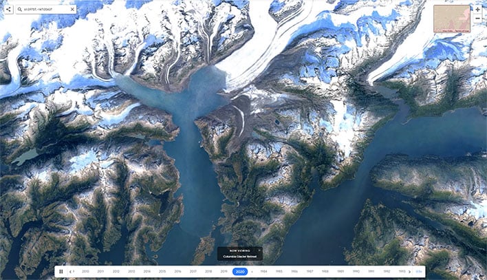
They are sort of guided tours, in a sense. If you choose Warming Planet, for example, Google Earth transports you to the south coast of Alaska to show a series of satellite images depicting changes to the Columbia Glacier from 1984 to 2020. Accompanying text highlights that it has retreated more than 12.5 miles to the north during that span, making it one of the fastest changing glaciers on the planet.
In this particular category, there are 10 slides in all, covering a variety of destinations and occurrences like an uptick in fires breaking out in Alberta, Canada, and extreme weather events such as hurricanes and typhoons, which have been observed to be increasing in frequency and severity.
"Our planet has seen rapid environmental change in the past half-century—more than any other point in human history. Many of us have experienced these changes in our own communities; I myself was among the thousands of Californians evacuated from their homes during the state’s wildfires last year," Rebecca Moore, director of Google Earth, explained in blog post.
This is not meant to be an interactive guilt trip on how people have contributed to certain changes on the planet. It is certainly educational, though, with Google having worked with experts at Carnegie Mellon University to create the technology behind its timelapse feature and "make sense of what we were seeing" in the collection of satellite images over time.
"We invite anyone to take Timelapse into their own hands and share it with others—whether you’re marveling at changing coastlines, following the growth of megacities, or tracking deforestation. Timelapse in Google Earth is about zooming out to assess the health and well-being of our only home, and is a tool that can educate and inspire action," Moore added.
Check it out and tell us what you think!


