World's Highest-Resolution Satellite Imagery
If you ever have that nagging feeling that you are being watched, you might not be wrong. But with your watcher being 423 miles above you, you might have a hard time confirming your suspicions. And while being spied upon from such a distance may seem like not much detail can be realized, you might be in for a surprise--the GeoEye-1 Satellite, which just achieved "full operational capability certification from the National Geospatial-Intelligence Agency" (NGA), can capture images on the ground down to 0.41 meters (or about 16 inches). GeoEye claims that the GeoEye-1 now delivers "the world's highest resolution, most-accurate satellite imagery."
The GeoEye-1 Satellite was launched last September, and "transmitted its first, full color half-meter ground resolution images" a month later. GeoEye-1 is part of the Department of Defense's (DoD) NextView program, which "is designed to ensure that the NGA has access to commercial imagery in support of its mission to provide timely, relevant and accurate geospatial intelligence in support of national security." By funding commercial satellite technology, the DoD ensures that the technological advances in satellite and imagery technology can serve both military and commercial interests. Only military sources, however, have access to images captured at the satellite's maximum ground resolution of 0.41 meters; Commercial clients' images are re-sampled at a 0.5-meter resolution.
Images captured at the GeoEye-1's maximum ground resolution of 0.41 meters are captured using a panchromatic (black-and-white) sensor; the GeoEye-1's maximum color ground resolution is 1.65 meters (or about 64 inches)--the satellite's electronics can process 700-million pixels-per-second. The GeoEye-1 is in a sun-synchronous, polar-orbit, traveling at 7.5km/sec (about 16,800-mph), and it can collect "up to 700,000 square kilometers in a single day, an area about the size of Texas, and in the multispectral mode 350,000 square kilometers per day; the equivalent of photographing in color the entire State of New Mexico." The GeoEye-1 makes just under 15 orbits per day (it has a 98-minute period) and can revisit virtually any location in less than three days.
GeoEye-1 started delivering imagery to commercial customers as of February 5, and now that the NGA has certified GeoEye-1 for its needs, the satellite is officially delivering images to the NGA as of today. Now that it is officially online for the NGA, GeoEye-1 will begin generating $12.5 million per month in revenue from the NGA for GeoEye. GeoEye's chief operating officer, Bill Schuster, stated, "we are already working on the advanced camera and camera electronics for GeoEye-2 and look forward to continuing to serve NGA with next-generation capabilities."
 |
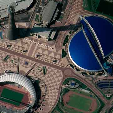
"Half-meter resolution image of Khalifa Sports City, Doha, Qatar, was collected by the GeoEye-1 satellite on January 10, 2009" (Credit: GeoEye) |
Images captured at the GeoEye-1's maximum ground resolution of 0.41 meters are captured using a panchromatic (black-and-white) sensor; the GeoEye-1's maximum color ground resolution is 1.65 meters (or about 64 inches)--the satellite's electronics can process 700-million pixels-per-second. The GeoEye-1 is in a sun-synchronous, polar-orbit, traveling at 7.5km/sec (about 16,800-mph), and it can collect "up to 700,000 square kilometers in a single day, an area about the size of Texas, and in the multispectral mode 350,000 square kilometers per day; the equivalent of photographing in color the entire State of New Mexico." The GeoEye-1 makes just under 15 orbits per day (it has a 98-minute period) and can revisit virtually any location in less than three days.
GeoEye-1 started delivering imagery to commercial customers as of February 5, and now that the NGA has certified GeoEye-1 for its needs, the satellite is officially delivering images to the NGA as of today. Now that it is officially online for the NGA, GeoEye-1 will begin generating $12.5 million per month in revenue from the NGA for GeoEye. GeoEye's chief operating officer, Bill Schuster, stated, "we are already working on the advanced camera and camera electronics for GeoEye-2 and look forward to continuing to serve NGA with next-generation capabilities."

